Beginning June 5, 1927, the Grand Belt line began providing service to the new DSR streetcar terminal yard at the Ford Rouge Plant. During shift change, a handful of Grand Belt cars would turn west off Junction onto Dix Road (renamed W. Vernor, c. 1929) and follow along the Baker car route to the Miller Road South Yard loop — one of two terminal yards located across the street from the plant. Service by the Grand Belt line to the Ford Rouge facility would continue on well into the DSR/D-DOT bus years.
MAJOR GRAND BELT ROUTE CHANGE:
By 1931, a major route change for the Grand Belt line had been implemented by the DSR, after the routes followed by the Grand Belt and the Crosstown (Warren and Forest) streetcar lines were swapped east of Mt. Elliott. The Crosstown line — which previously traveled along Forest Avenue, but then turned south onto Mt. Elliott, to Kercheval, Concord, Lafayette, and Field to E. Jefferson Avenue (near the entrance to the Belle Isle bridge) — was rerouted, and would now continue east along Forest, Cadillac and E.
Warren to St. Jean. The Grand Belt car line would now continue south along Mt. Elliott, along the former Crosstown route to Field and E. Jefferson.
As a result of this route reassignment, Grand Belt now formed a "belt-shaped" route around the central city, operating along Mt. Elliott on the east, Milwaukee, Ferry Park and McGraw streets along the north, and Junction on the west. The Crosstown now followed a more across-the-town route along Warren and Forest avenues.
| . |
Although the former route #20 Grand Belt — cancelled by the city's Department of Transportation (DDOT) bus system in 2009 — traveled a substantial portion of its route along the city's "Grand Boulevard" roadway, the former Grand Belt streetcar line, however, never operated along Grand Blvd. Nevertheless, the Grand Belt bus line can still trace its history back to this original streetcar route.
THE D.U.R. YEARS:
The original Grand Belt line began as a new streetcar route built by the former Detroit United Railway (DUR) — the privately-owned streetcar company in operation prior to the city take-over in 1922. It was one of the last new rail lines constructed under the DUR. The Grand Belt line began service on Nov. 30, 1916, and operated via a belt-shaped route that included new trackage along E. Forest, Milwaukee and Ferry Park streets. The new line also took over the service of the Junction Avenue Belt line — which began its operations on Oct. 28, 1914.
According to DUR route information publications from the late-1910s, the heavy traveled Grand Belt route began at the east side city limits at E. Warren and Bewick, and operated via the following route:
E. Warren, Cadillac, Forest, Gratiot, Mt. Elliott, Milwaukee (return via Baltimore, btwn Lincoln and Brush), Lincoln, Holden, Ferry Park, Fourteenth, W. Warren, Junction (SB via 35th, btwn Devereaux and Michigan back to Junction), to Fort Street where it looped at Clark Street.
| . |
| Click here to return to the "BUS ROUTE HISTORY" Main Page. |
| The History of the Former... GRAND BELT STREETCAR LINE |
|

Consequently, portions of the Grand Belt route, including new trackage built along Milwaukee, Baltimore, Lincoln, Holden, Ferry Park, Junction and 35th streets, were seized and purchased by the city, forcing the DUR to lease those portions of the route from the city in order to continue operating its cars over those rails. The city, under its competing municipally-owned operation (launched on Feb. 1, 1921), was now able to extend its new Clairmout line over portions of the Grand Belt route starting on Jan. 15, 1922.
| . |
| (Grand Belt rail map (illustrated by Richard Andrews) and 1941 DSR streetcar route info all courtesy of the S. Sycko Collection) |
1922-1956" by Schramm, Henning, and Dworman (Bulletin 120 - Central Electric Railfans' Association), and from Jack E. Schramm articles found under
"Detroit's DSR, Parts 1 thru 3" published by Motor Coach Age Magazine. Information was also obtained from miscellaneous artifacts courtesy of the Stan
Sycko collection. Grand Belt route map illustration by Richard Andrews.
| A typical DSR Grand Belt streetcar 1¢ transfer issued in 1942. (Transfer courtesy of the S. Sycko collection) |
| A typical "free" Grand Belt streetcar transfer issued during the Detroit United Railway (DUR) years. (Transfer courtesy of the Stan Sycko collection) |
Initial plans were for the Grand Belt line to also be included in a joint-service operation. The city had intended to use the joint-operation on Grand Belt to provide branch service for the city-operated cars along new trackage the city was building along Linwood and McGraw streets. Instead of turning at Fourteenth, the city cars would continue along Ferry Park to Linwood, then via Linwood, McGraw and W. Warren to Junction.
Although the trackage along McGraw Street was still under construction, thus delaying a joint operation, it appears that on March 8, 1922, the M.O. began some service on a McGraw line from Ferry Park and Linwood to McGraw and Grand River. As it turned out, the joint service operation initially planned for Grand Belt would not be necessary, as the city's newly-launched Department of Street Railways (DSR) took-over all DUR city operations on May 15, 1922.
THE EARLY D.S.R. YEARS:
On June 26, 1922 (shortly after the city took over the lines), the Grand Belt was merged with the short McGraw line and rerouted along the now completed McGraw street trackage. The Grand Belt now operated via Linwood, McGraw and W. Warren to Junction, instead of Fourteenth and Warren.
Meanwhile, the east-side portion of the route was extended six-tenths-of-a-mile east of Bewick via new trackage built along E. Warren that now connected to the new DSR Shoemaker Carhouse at St. Jean. A new turn-around loop just south of the carhouse — the St. Jean Loop — would become the new east-end terminus for the Grand Belt line.

| Under both the DUR and DSR, Grand Belt streetcars operated along Junction Ave between Warren Ave and Fort Street. This 1948 photo shows DSR Peter Witt car #3320, southbound on Junction, just south of Michigan Ave, while working the Grand Belt line. (Thomas C. Van Degrift photo, from CERA Bulletin #120) |
The Grand Belt line was considered a medium-to-heavy traveled route, and daily carried hundreds of auto workers to their jobs. It serviced numerous auto and auto-related manufacturing facilities along its route, including the Hupp Motor Car Co. (Milwaukee and Mt. Elliott), the Fisher Body plants (along Mlwaukee), the GM Headquarters Bldg., the Cadillac (Clark Street) Plant (near Junction), and the Timken-Detroit Axle Co. at Fort and Clack streets, in addition to branch service to the Ford River Rouge plant in Dearborn.
| . |
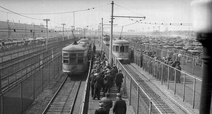
| This 1937 photo looks north along the DSR Miller Road South Yard across from the Ford River Rouge auto complex (far left). The Grand Belt, Baker and Fort Street cars would access the south yard via the Eagle Pass near Eagle Ave and Wyoming. The south yard terminal had the capacity to load 20 cars and unload 20 cars simultaneously, and store 32 more. The three tracks to the right were used to board workers from pre-payment booths above, while the far left track was used to unload. (Walter P. Reuther Library, Wayne State University photo #7589 — see disclaimer below) |
By the arrival of the early post-war years, the Grand Belt's days as a streetcar line would soon be numbered. Effective June 24, 1948, the Grand Belt streetcar line was converted over to motor bus operation — thus becoming the DSR's sixth streetcar line to be abandoned after the war.
Although most of the route initially remained unchanged after the conversion to buses, one major change occurred on the west end of the route. Under the motor bus operation, Grand Belt service along Junction Avenue was immediately discontinued and its coaches rerouted to continue along McGraw Street to the route's new terminus at the Wyoming Terminal Loop on Wyoming just south of Michigan Avenue. As a result, the extended Grand Belt service to the Ford Rouge plant was also rerouted, and now operated via Wyoming and Eagle to Miller Road.
The former Grand Belt service along Junction Avenue to Fort Street was immediately reassigned to the Clairmount streetcar line, which up until then terminated at Junction and Michigan Avenue.
All rights, including those of further reproduction and/or publication, are reserved in full by the Walter P. Reuther Library, Wayne State University. Photographic
reproductions may be protected by U.S. copyright law (U.S. Title 17). The user is fully responsible for copyright infringement.
| (Reformatted 11-24-14) |
| . |
| CLICK HERE TO PRINT TEXT–PAGE |